About Alvarado Gardens Neighborhood
Alvarado Gardens Neighborhood Association (AGNA) is the official city-recognized association for this neighborhood.
Uniqueness of Alvarado Gardens
- Rural & agricultural in character, yet within the city limits.
- Closely tied to the Rio Grande and its inner valley, yet minutes from downtown.
- A neighborhood where five‑acre estates are adjacent to thirty‑year old, tree‑shaded trailer parks.
- Home to a variety of cultural groups that coexist with a common bond: the desire to live in an area more closely involved with the natural environment than anywhere else in the city, while enjoying (and being willing to be taxed for) city services and urban advantages.
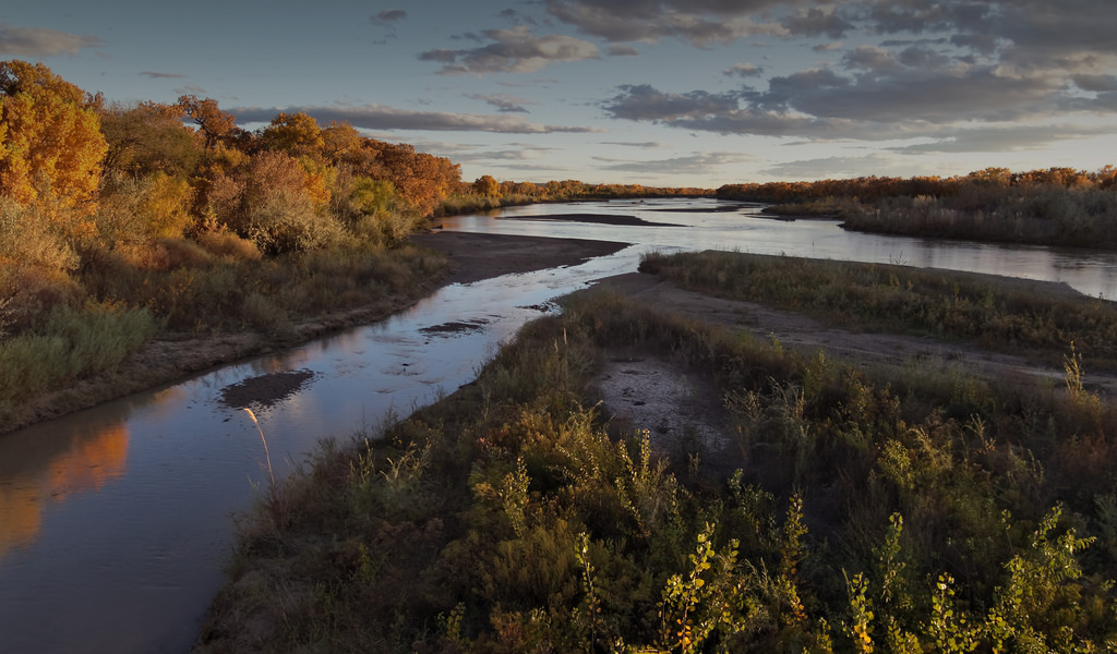
Alvarado Gardens Neighborhood is bounded by the Rio Grande Bosque on the west, Rio Grande Boulevard on the east, Candelaria and Veranda Roads on the north, and Campbell and Vicic Roads on the south. The area has maintained an open and agricultural character since it was settled in the 1930's, attracting residents who enjoy raising livestock, growing crops, and living in a non‑suburban setting. This neighborhood probably also contains a greater diversity of socio‑economic groups than anywhere in the city. As are many or most neighborhood plans, the one for this area is centered around the issue of maintaining the special character of the Alvarado Gardens neighborhood. The existence of a rural/urban neighborhood is an asset to the entire city for several reasons:
- It provides diversity and choice in lifestyles for residents ofAlbuquerque; no other area shares its advantages.
- Residents of this neighborhood pay taxes and are a part of the city, unlike many valley residents living in the county who have been called "parasites" on city services.
- The large influx of people from all over the city (and county) to this neighborhood to visit the Rio Grande bosque, use the recreational trails, visit the Nature Center, swim or raft in the Rio Grande, experience relief (visually and emotionally) from the urban environment, demonstrates the importance and need for this kind of environment.
It must be clearly stated, however, that it is not the intention of this neighborhood plan to attempt to restrict development. It is, rather, to draw to the attention of city officials, developers, and all city residents, that this neighborhood has the assets and special character described, so that new development or changes will reflect and enhance this character. We hope that most people’s vague awareness of an area between the Thomas Village Sub division and Rio Grande Nature Center will be crystallized into clear recognition of an interesting, vital neighborhood with unique characteristics requiring special consideration. If the special nature of this neighborhood is not preserved, not only residents of the neighborhood, but all city residents will be the losers.
Geologic History
The Alvarado Gardens Neighborhood is dominated not only visually, but functionally by its location in the inner valley of the Rio Grande Trough. Geologically speaking, the Rio Grande Trough is relatively young—only 10–20 million years old. It was not carved by the Rio Grande, but rather was formed by simultaneous uplift (and tilting) of the SandiaMountains and subsiding of the depression where the Rio Grande later began to flow. The trough subsided about 26,000 feet, which means that there is about 20,000 feet of sediment which has been filled in since the trough was formed. The Rio Grande has been the agent which filled this huge valley with sand, mud and gravel. The River meandered across the large floodplain including what are now the east and west mesas, gradually filling in the trough until about 100 thousand years ago when it then began to erode and carved the inner valley. About 20,000 years’ago, it began to fill the inner valley again, the process which would be continuing today if the river were not controlled within its present channel. This inner valley is where Alvarado Gardens Neighborhood is located.
Geology and Hydrology of the Inner Valley
Because the Rio Grande has been restricted to its present channel since the 1870’s, it has deposited sediment only in that channel and not evenly across the inner valley as it would normally do. Thus the river bed is higher than the surrounding area. Starting in the late 1800’s the inner valley increasingly become a marsh, often with standing water. By the 1930’s, the Middle Rio Grande Conservancy District built drains to lower the water table to the point where the neighborhood could be farmed and people could live in the inner valley, including Alvarado Gardens . Irrigation ditches and levees to contain the river were also built.
Since Cochiti Dam was built in 1973, much of the river sediment is being deposited in the reservoir, and the channel of the Rio Grande in the Albuquerque area is no longer aggrading. However, its level will likely remain above that of surrounding areas, and only by continued maintenance of the levees and drains can the river be restrained from following its natural meandering course across the inner valley.
The water table in the Alvarado Gardens Neighborhood presently ranges from about 5 to 20 feet below the surface, depending on factors such as distance from the river or surface water in irrigation ditches. No major change in these levels is expected to occur over the next 20 years. The depth to water table is important in this neighborhood; irrigation wells and pumps can be affected if the water table drops, and use of septic tanks is limited when the water table is shallow. Building of basements or other subsurface structures is also limited by shallow water tables. Although most residents of Alvarado Gardens are served by City water, it is important in our area not to pollute the ground water by improper use of septic tanks. It is also important that these people with irrigation or domestic water wells still in use not have interconnection of their water lines with city water lines in their homes, so that they do not contaminate city water with water from private wells.
Soils
The Alvarado Gardens Neighborhood area include several soil types, as can be seen on the accompanying map. In the yel low area, the soil is very good and has essentially no limitations for agriculture or development. In the green areas, there is a 20–36 inch layer of clay‑rich soil which is underlain by sand. This area has no limitations for agricultural uses but land leveling that should be limited because of the shallow soil layer. The blue area soils have even greater limitations than the green. The clay‑rich layer of soil overlying sand is only 11–20 inches thick. The greater amount of sand makes the soil more subject to blowing than the other soil categories; therefore, it is preferable to grow alfalfa or pasture grasses rather than row crops which dry out faster. Land leveling may create problems in this area also.
Natural History: Plant and Animal Life
An aerial view of Alvarado Gardens is green from April to October; gold, white, or brown in the fall and winter. A closer look would reveal twenty‑two varieties of native grasses, as well as the lawn grasses introduced by residents. Yellow, violet, and orange wildflowers predominate among the twenty‑eight kinds that have been identified here. Large cottonwoods along the bosque are a part of the world’s largest cottonwood stand. The understory of Russian olive, willow, and tamarisk are complemented by garden and fruit trees. Several orchards grew along Candelaria Road until they were replaced by homes in the early 1960s and in the 1980s. A majority of residents now have garden plots which often include plum, pear, cherry, pecan, or apple trees. The high water table allows the growth of trees that are unable to survive in other parts of the city.
It is likely that primitive mammals around 100 million years ago inhabited this area and that longhorn bison and giant ground sloth once roamed through this part of the valley. The riparian, agricultural, and populated habitats of the neighborhood now provide homes and food for an extraordinary variety of animals. The site for the Rio Grande Nature Center was chosen partly because it is a place where various habitats meet and therefore attract a diversity of native wildlife and wildfowl from the Rio Grande Flyway The settlement of the area in this century brough t in a vast number of cats, dogs, fowl, burros, sheep, cattle, horses, and an occasional goat and guinea pig. These pets and livestock share the space with the wild creatures whose patterns have become familiar to residents. Spring means the emergence of crayfish in the network of ditches. Neighbors put out feeders and plant flowers for the hummingbirds’ arrival from the tropics in April. In February and October, thousands of sandhill cranes and snow geese fly low over the area, alerting residents of their flight with raucous honks. Many splayed‑flat toads can be found under the street lights of Alvarado Gardens where the fat toads have foolishly gone to catch insects attracted by the light. The local insects also are food for the more than forty‑six resident species of birds and the more than 300 visiting varieties, recorded through a bird‑banding and netting program conducted in the neighborhood. Area skunks have a pattern of getting into garbage bags and of occasionally killing a chicken. Beavers leave toothmarks on trees and shrubs along the ditches. Great horned owls and sparrow hawks perch in branches of the old cottonwoods or dead elms along the river.
Settlement History
Although no prehistoric sites have been identified here, the Center for Anthropological Studies has found possible prehistoric features in Alvarado Gardens. Gardeners occasionally unearth potshards and worked stones probably left by Tiwas who inhabited the Albuquerque area. Spanish colonists probably farmed the region during the eighteenth and nineteenth centuries, but a shifting river course and periodic flooding precluded the construction of homes until flood control efforts of the 1930s.
Subdivision Platting and Recent Developments
The Yonemoto family operated a truck farm and eventually built houses for themselves and for workers at the end of Candelaria Road after flood control measures had been taken. The Louis Palmer slaughterhouse, built near the end of Campbell Road, was the destination for cattle driven down the wide dirt roads leading toward the river. The small ditch adjacent to the clear ditch or “acequia madre” was used for the disposal of offal. A government experimental sheep station operated on the south side of Candelaria near Rio Grande Boulevard. These agricultural businesses closed after the number of housing units increased. The area became part of Albuquerque in October 1952. Zoning for the Alvarado Gardens neighborhood was all A‑1 in 1950. In May, 1954, an R‑2 zoning change was made for the area between the Duranes ditch and Glenwood Road . In 1978, the zoning for the site of the Rio Grande Nature Center was changed to SU‑1. The last large agricultural land holding within the City of Albuquerque is Candelaria Farms within the Nature Center, where alfalfa and sorghum are raised to benefit the center’s bird population as well as the leasing farmers.
Alvarado Gardens was platted in 1931. Homes have been built at a slow, steady pace since then. Modest adobe rectangles, vintage mobile home parks , large solar‑heated villas, modern town houses, and sturdy frame or adobe homes share the streets in irregular order on lots that conform to the predominant land pattern created by the irrigation ditches. Landscaping ranges from casual to precise, from barren to luxuriant. The Alvarado Gardens community has welcomed and supported the fire station at Oro Vista and Rio Grande, the All Faiths Receiving Home on Trellis, and the Rio Grande Nature Center on Candelaria. These institutions serve the greater Albuquerque community, as do the storm sewer outfall pump station and the bicycle trail. Hundreds of joggers and bicyclists emerge each weekend from the end of the trail at Candelaria and fan out through Alvarado Gardens to head home or to complete a marathon loop through the neighborhood.